
Share this:

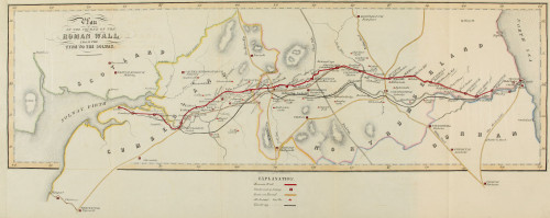

Map of Hadrian’s Wall, 1851.
This scanned print of the original from ‘The Roman Wall’ by John Collingwood Bruce (1805–92), first published in 1851 shows the plan of the course of the Roman wall from the Tyne to the Solway


More Stories
Will County, Illinois 1864 Map – May 20, 2023 at 04:14AM
This kid on Google Map trying to get by – April 27, 2023 at 05:05PM
World of Hyatt: Complete list of all-inclusive properties in Europe (with map) – April 27, 2023 at 04:57PM